
Wednesday, April 16 2025 - MUC, Sevilla and Dos Hermanas
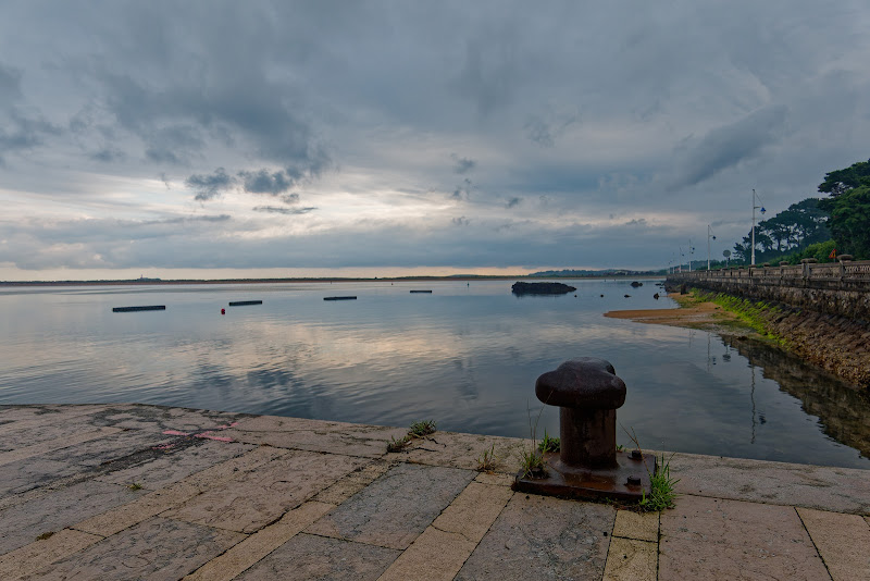
12.30 at Sevilla Airport, bike and luggage fine, about an hour later I was on the road, bought some camping gas at the local Decathlon, and made a quick trip through the city centre of Sevilla. Very crowded around easter since it was Semana Santa de Sevilla with many Nazarenos and their distinctive pointed hood (capirote) on the streets. Leaving Sevilla to the south and found a campsite in Dos Hermanas. Just about 50km on the bike, but it was still a long day...


Sevilla
Sevilla, the capital of Andalusia, is a city with a rich cultural tapestry rooted in its diverse history. The architecture reflects influences from the Moors, Christians, and Jews, with landmarks like the Giralda tower and the Alcázar of Sevilla showcasing this blend. The Giralda, originally a minaret, now serves as the bell tower for the Cathedral of Sevilla. The Alcázar, a royal palace, is a prime example of Mudejar architecture, symbolizing the city's historical significance.
The Guadalquivir River runs through Sevilla, historically serving as a vital trade route that contributed to the city's prosperity and cultural exchange. The river's banks are lined with paths for strolls, and the Triana neighborhood, located across the river, is known for its traditional pottery and flamenco heritage. This area provides insight into the local way of life and its artistic traditions.
Sevilla's culinary scene is characterized by Andalusian flavors, with tapas bars offering small plates that highlight local ingredients such as Iberian ham and fresh seafood. The Mercado de Triana is a market where local produce and delicacies can be found. The city's annual Feria de Abril celebrates Andalusian culture with traditional music, dance, and cuisine, drawing both locals and visitors to enjoy the festivities.


Thursday, April 17 2025 - Rain in Spain
Not much, but it actually made cycling more pleasant. Lots of modern windmills and solar panels at the fields. Via Arcos de la Frontera (the Roman Arx-Arcis (fortress on high ground) became the Moorish Medina Arkos and gained the latter part of its name by being the frontier of Spain's 13th-century battleground with the Moors). Medina Sidonia had a nice campground.


Medina Sidonia
Medina Sidonia, located in the province of Cádiz within Andalusia, Spain, is a city steeped in history and cultural significance. Often considered one of the oldest cities in Europe, its strategic elevation has historically made it a key military defense location. The city's name, derived from the Arabic "Medina" meaning "City" and "Sidonia" from the ancient city of Sidon, reflects its deep historical roots. The locals, known as Asidonenses, take pride in their city's rich heritage, which includes its role as an important ducal seat in the 15th century.
The city's historical significance is further highlighted by its connection to the Spanish Armada through Alonso Pérez de Guzmán, the 7th Duke of Medina Sidonia. The title of Duque de Medina Sidonia was awarded to the family of Guzmán El Bueno for their valor, and the lineage continues to this day. Medina Sidonia's ancient origins are evident in its archaeological findings, with coinage from the 2nd and 1st centuries BC bearing Latin and Punic inscriptions. The city, once known as Asido Caesarina under Roman rule, has seen various rulers, including the Visigoths, Byzantines, and Muslims, each leaving their mark on its cultural landscape.
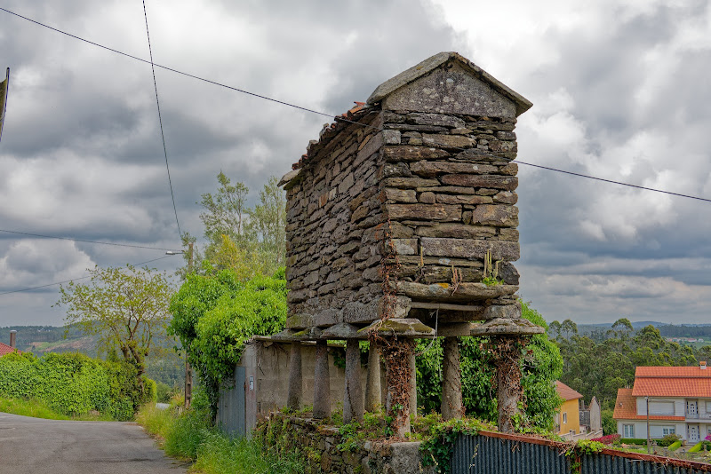
Today, Medina Sidonia is characterized by its medieval walls, narrow cobbled streets, and reja-fronted houses. The town boasts several historical sites, such as the Castle of Medina-Sidonia, Roman archaeological complex, and the Church of Saint Mary the Crowned. These landmarks, along with the town hall, La Alameda, and Ducal Stables, reflect the city's architectural evolution over the centuries. Medina Sidonia's rich history and well-preserved sites offer a glimpse into its storied past, making it a notable location within the Andalusian region.


Friday, April 18 2025 - Tarifa, Algeciras, Palmones
Early up on a hot day. Along the coast was not flat and easy. Made a overnight stop in Palmones with nice views to Gibraltar. In Tarifa I got delayed by a Good Friday Procession. Did not see any Nazarenos with their pointy hats like in Sevilla. Cycling between Algeciras and Palmones, cycling the motorway was ok (legally and concerning traffic), openstreetmap would send you on detours that are not necessary.


Vejer de la Frontera
Vejer de la Frontera is a Spanish hilltop town and municipality in the province of Cádiz, Andalusia, on the right bank of the river Barbate. The town of Vejer de la Frontera occupies a low hill overlooking the Straits of Gibraltar and surrounded by orchards and orange groves. It contains several ancient churches and convents, and the architecture of many of its houses recalls the period of Moorish rule, which lasted from 711 until the town was captured by Saint Ferdinand of Castile in 1248. Agriculture and fruit-farming are the chief industries; fighting bulls are also bred in the neighborhood and a running of the bulls is held annually.


Tarifa
Tarifa, located at the southernmost tip of the Iberian Peninsula in the province of Cádiz, Andalusia, is renowned for its windsports, drawing enthusiasts from around the globe. Positioned on the Costa de la Luz and facing Morocco across the Strait of Gibraltar, Tarifa includes several villages such as Tahivilla, Facinas, and Bolonia. The area is historically significant, with Roman ruins like Baelo Claudia near Bolonia Beach, and its name originates from the Islamic conquest by Tarif ibn Malik in 710.
Throughout history, Tarifa has been a strategic military site, fortified from the 10th century and changing hands among various rulers, including the taifa of Algeciras, the Almoravids, and the Kingdom of Granada. It was conquered by Sancho IV of Castile in 1292 and withstood multiple sieges, notably resisting Marinid forces in 1340. Despite its defenses, Tarifa remained sparsely populated during the Middle Ages, serving as a crucial base for the Castilian navy after the destruction of Algeciras in 1369.
In the 16th century, Tarifa's economy diversified with fishing and husbandry, and it became part of the seigneurial land of the Adelantado Mayor de Andalucía. The town's population grew, reaching around 3,500–4,000 by 1587. During the Peninsular War, Tarifa was besieged by French troops but successfully defended by British and Spanish forces. The town's name, derived from the military commander Tarif ibn Malik, reflects its rich historical legacy and strategic importance over the centuries.


Gibraltar
Gibraltar, a British Overseas Territory located at the southern tip of the Iberian Peninsula, is strategically positioned at the entrance of the Mediterranean Sea. It covers an area of 6.8 km² and is bordered to the north by Spain. The territory is dominated by the Rock of Gibraltar and is home to approximately 34,003 people, primarily Gibraltarians. Founded by the Almohads in 1160, Gibraltar has changed hands multiple times, including control by the Nasrids, Castilians, and Marinids, before becoming part of the Crown of Castile in 1462. Captured by Anglo-Dutch forces in 1704, it was ceded to Great Britain under the Treaty of Utrecht in 1713, becoming a key naval base.
The sovereignty of Gibraltar remains a contentious issue in Anglo-Spanish relations, with Spain asserting a claim to the territory. However, Gibraltarians have consistently rejected proposals for Spanish sovereignty in referendums held in 1967 and 2002. Despite this, Gibraltar maintains close economic and cultural ties with Spain, with many residents speaking both Spanish and the local dialect, Llanito. The economy of Gibraltar is supported by financial services, e-gaming, tourism, and its port, with a significant portion of the labor force residing in Spain.
Since Brexit, Gibraltar is no longer part of the European Union, but negotiations are ongoing to include it in the Schengen Agreement to ease border movements with Spain. The name Gibraltar is derived from the Arabic "Jabal Ṭāriq," meaning "Mount of Tariq," named after Tariq ibn Ziyad, who led the Muslim conquest of the Iberian Peninsula in 711.

Algeciras
Algeciras, a city and municipality in the province of Cádiz, Andalusia, is situated at the southern end of the Iberian Peninsula near the Strait of Gibraltar. It is the largest city on the Bay of Gibraltar and plays a significant role in the region's economy. The Port of Algeciras is among the largest in Europe and the world, known for its container, cargo, and transshipment activities. The city is bisected by the Río de la Miel, the southernmost river in continental Europe, and as of January 2020, it had a population of 123,078, making it the second-largest city in its province.
The metropolitan area of Algeciras includes neighboring municipalities such as Los Barrios, La Línea de la Concepción, Castellar de la Frontera, Jimena de la Frontera, San Roque, and Tarifa, collectively housing a population of 263,739. This area forms part of the comarca of Campo de Gibraltar, contributing to its cultural and economic landscape. The city's historical roots are reflected in its name, derived from the Arabic al-Jazīrah al-Khaḍrāʾ, meaning "The Green Island," a reference to Isla Verde.
Historically, Algeciras was the site of Roman cities like Portus Albus, Caetaria, and Iulia Traducta. During the Byzantine period, it was known as Mesopotámenoi, meaning "between rivers/canals" in Greek.


Saturday, April 19 2025 - Ronda
Rain in the morning and lots of traffic on the motorway towards Gibraltar. Had nice views last evening of the rock and decided to head for the mountains instead. First (very) demanding detour: Castellar de la Frontera. Downhill on a very rough trail. There was deep muddy water when it got flat. Lunch in Jimena de la Frontera and then many hills with up and down to Ronda. Weather mixed and strong headwinds.


Sunday, April 20 2025 - Heart of Andalucia
Rain from the start in Ronda, a very bold city built on the edge. Went for a coffee in Cuevas del Beccerro to warm up a bit. That was a very lively place, people not only had drinks there but bought bread, jam, butter and many other things for a breakfast at home. Via the big lake Guadalhorce-Guadalteba and with lots of up and down to the city called the heart of Andalucia, Antequera.


Ronda
Ronda is a picturesque municipality in Spain, located in the province of Málaga within the autonomous community of Andalusia. Known for its dramatic cliffside position and the deep canyon that divides the town, Ronda is home to approximately 35,000 residents. The town is part of the Sierra de las Nieves National Park, adding to its natural allure. Ronda's historical significance is highlighted by its prehistoric settlements, including the Neolithic rock art of Cueva de la Pileta, and its association with ancient places like Arunda and Acinipo, as mentioned by Pliny the Elder.
Throughout its history, Ronda has seen a succession of rulers and influences. It was conquered by the Suebi in the 5th century, later falling under the Eastern Roman Empire, and eventually becoming part of the Visigothic Kingdom. In 713, the Umayyad Caliphate took control, naming it Hisn al-Rundah. The town became a center of Islamic culture, producing notable figures like polymath Abbas ibn Firnas. After the fall of the Caliphate of Córdoba, Ronda became the capital of a small Berber kingdom, the Taifa of Ronda, and later fell under the Taifa of Seville. The Christian conquest in 1485 by the Crown of Castile marked a significant shift, with policies encouraging Christian settlement while maintaining a Muslim majority in rural areas.
The 19th and 20th centuries brought further challenges and changes to Ronda. The Napoleonic invasion and the Peninsular War drastically reduced its population, and the area became a hub for guerrilla warfare and banditry, inspiring artists like Washington Irving. The Romero family of Ronda played a crucial role in the evolution of modern Spanish bullfighting. The Spanish Civil War had a profound impact on the town, leading to emigration and depopulation. Ronda's dramatic landscapes and rich history have made it a source of inspiration for literature, notably influencing Hemingway's depiction of the Spanish Civil War in "For Whom the Bell Tolls."


Antequera
Antequera, often referred to as "the heart of Andalusia," is a city and municipality in the Comarca de Antequera, province of Málaga, within the autonomous community of Andalusia, Spain. Known for its central location among major cities like Málaga, Granada, Córdoba, and Seville, Antequera is home to the UNESCO World Heritage site, the Antequera Dolmens Site. As of 2011, the city had a population of 41,854, covering an area of 749.34 km², making it the most populous city in the interior of the province and the largest in area. Its strategic location is enhanced by its connectivity through high-speed trains and motorways, making it a burgeoning center for transportation logistics and agriculture.
The city's history dates back to ancient times when it was known to the Romans as Anticaria or Antiquaria. It was part of the lands of Tartessos and later the Turdetani, known for their civilization among the Prehistoric Iberians. The Carthaginians expanded into the region during the 230s BCE, and the Roman Republic eventually took control following the Second Punic War. Under Roman rule, Anticaria became part of Hispania Baetica, known for its high-quality olive oil. The area was heavily Romanized, with many colonies established, and the street plan of Antequera largely follows the Roman layout. The region became increasingly Christianized after the second century.
During the fall of the Roman Empire, the area fell to the Siling Vandals and later the Visigoths, who converted to Arian Christianity. The Arab invasion of the Iberian Peninsula in 711 led to the conquest of Anticaria, renamed Medina Antaquira under the Umayyad Caliphate. The city became an important border town during the Reconquista, with fortifications built to defend against Catholic Spanish troops. In 1410, Antequera capitulated to a Castilian army led by Ferdinand of Trastámara, leading to the expulsion of the Muslim population and the settlement of Christians. The city became part of the Kingdom of Seville and served as a major military power base during the War of Granada.
In the early modern period, Antequera's economy shifted from a military-focused to an agricultural one, becoming a key cereal production center. Its strategic location made it an important commercial town, earning it the title "Heart of Andalusia." The city saw cultural growth with the founding of the Real Colegiata de Santa María la Mayor in 1504, fostering a school of poets and sculptors. However, by the late seventeenth and early eighteenth centuries, Antequera's prosperity waned due to Spain's economic crisis following the loss of its American colonies and military conflicts in Europe. The decline affected the city's patrons of the arts, leading to a slowdown in cultural and architectural development.


Monday April 21 2025 - Arrival in Granada
Took the northern route via Archidona on the mountain and Loja to Granada. About 115km today, lots of short, steep climbs. Had to cross a small river that came from nowhere, about 50cm deep. Nice campsite in Granada, the beautiful view comes at a price: you have to cycle up an hill.


Tuesday, April 22 2025- Through Mountains
Granada until midday. What a city, such winding and steep streets. Entering Sierra Nevada and cycled along with the teams from Cofides and Emirates, who were training with their teams and cars with spare bikes. Stayed in Guadix. The town with the caves. I am in a pilgrims hostel and have my first stamp in my pilgrim passport. 1000 year old building, the owner is a writer and theater person. The stage can be seen here in the garden from the kitchen.


Granada
Granada, the capital city of the province of Granada in Andalusia, Spain, is renowned for its rich history and cultural heritage. Nestled at the foot of the Sierra Nevada mountains and intersected by four rivers, Granada is a city of both natural beauty and historical significance. With a population of approximately 231,775 as of 2021, it ranks as the 20th-largest urban area in Spain. The city has been a significant settlement since ancient times, inhabited by Iberians, Romans, and Visigoths, and later becoming a major city of Al-Andalus during the 11th century under the Zirid Taifa. It rose to prominence as the capital of the Nasrid Emirate of Granada, the last Muslim-ruled state in the Iberian Peninsula, until its conquest by the Catholic Monarchs in 1492. Granada is home to the Alhambra, a stunning example of Islamic architecture and one of Spain's most visited tourist sites. The city's architectural landscape also includes the Albaicín neighborhood, showcasing Moorish influences, alongside Mudéjar, Renaissance, Baroque, and Churrigueresque styles.
The region around modern-day Granada has been inhabited since at least 5500 BC, with archaeological evidence indicating continuous settlement from the Bronze Age. The earliest known settlement, Ilturir, was established by the Iberian Bastetani tribe around 650 BC. The identification of Granada with the Roman-era Iliberis is debated, but significant Roman remains have been found in the Albaicín area. Following the Roman period, the region's history is less documented until the 11th century. The Synod of Elvira, a significant Christian meeting around 300 AD, is believed to have occurred nearby, though its exact location remains uncertain. The Umayyad conquest in 711 AD brought the area under Moorish control, establishing al-Andalus. The settlement of Madīnat Ilbīra became the region's main center, while a smaller Jewish settlement, Ġarnāṭa, existed nearby.
In the early 11th century, the Zirids, a Berber group, gained control of the province of Elvira and established the Taifa of Granada. Zawi ben Ziri, a Zirid leader, moved the capital from the vulnerable Madīnat Ilbīra to the more defensible Ġarnāṭa, transforming it into a major city of al-Andalus. The Zirids built a citadel on the Albaicín hill, and the city expanded, fortified with walls and supplied with water through an intricate system. Under Zirid rule, Granada became a center of Jewish culture, with Samuel ha-Nagid, a Jewish administrator, wielding significant power. However, his son Joseph's lack of diplomacy led to the 1066 Granada massacre, ending the Jewish Golden Age. The city later fell under the control of the Almoravids and Almohads, North African Berber empires, with Granada serving as an administrative capital. The city thrived under the Almoravids but declined under the Almohads, leaving behind remnants like the Alcázar Genil and architectural influences in the Albaicín.
The Nasrid Emirate of Granada, established by Muhammad I (Ibn al-Ahmar) in the 13th century, was the last Muslim dynasty in the Iberian Peninsula, emerging as Almohad rule collapsed and the Christian Reconquista advanced. Granada became a tributary state to the Kingdom of Castile, with its political history marked by alliances and conflicts with both Christian and Muslim neighbors. The emirate's population swelled with Muslim refugees from territories conquered by Castile and Aragon, leading to a densely populated, predominantly Muslim, and Arabic-speaking region. The city expanded, with new neighborhoods and fortifications, and became a center of trade, specializing in high-value goods like silk and dried fruits, connecting with European and Muslim trade networks.
Granada was also a significant Islamic intellectual and cultural hub, particularly under Muhammad V, attracting scholars like Ibn Khaldun and Ibn al-Khatib. The construction of the Alhambra on the Sabika hill began under Ibn al-Ahmar, evolving into a self-contained palace-city with celebrated palaces like the Comares Palace and the Palace of the Lions. Despite its frontier position, Granada maintained a vibrant cultural life, with figures like the traveler Ibn Battuta praising it as the "metropolis of Andalusia." The emirate's economy and culture thrived partly due to its strategic trade connections, although it faced constant military pressures from Castile.
The end of Muslim rule in Granada was marked by the surrender of the Emirate of Granada to the Catholic Monarchs, Ferdinand II and Isabella I, on January 2, 1492, following the Granada War. The Treaty of Granada initially allowed Muslims, known as mudéjares, to practice their faith, but tensions rose as the Alhambra Decree soon forced Jews to convert or leave. Cardinal Francisco Jiménez de Cisneros's forced baptisms led to the Rebellion of the Alpujarras (1499–1501), after which the Crown of Castile mandated Muslim conversion or emigration. The 16th century saw Granada's transformation into a Catholic and Castilian city, with a significant influx of Christian immigrants and the conversion of mosques into churches. The University of Granada was founded in 1531, and the city developed new institutions. Despite the Second Morisco Rebellion in 1568, King Philip II ordered the expulsion of most moriscos from Granada, redistributing them across Castile, culminating in the final expulsion of all moriscos from Spain between 1609 and 1614.
In the 17th century, Granada's population stagnated at around 55,000, contrasting with rural population growth in the Kingdom of Granada, which had suffered from the earlier expulsion of the moriscos. The city was overshadowed by Seville and Madrid. During the Peninsular War, Napoleon's troops occupied Granada, damaging the Alhambra, but it was saved from complete destruction by Spanish intervention. Washington Irving's 1830 visit and his Tales of the Alhambra revived international interest in Granada's Islamic heritage. In the 1930s, Granada experienced social tensions, aligning with the Nationalists during the Spanish Civil War, with local resistance brutally suppressed. Under Franco, Granada was one of Spain's poorest provinces, but in recent decades, tourism has become a major industry, revitalizing the city's economy.


Guadix
Guadix, a city in southern Spain's province of Granada, is situated at an altitude of 913 meters in the Hoya of Guadix, near the Sierra Nevada. The area has been inhabited since the Bronze Age, with the ancient Roman settlement of Acci located nearby. Acci, mentioned by Pliny and Ptolemy, was a significant center during Roman times, known for its urban planning, craftsmanship, and industry, including kilns and possibly an oil press. Julius Caesar established the Roman colony Julia Gemella here, which became an important commercial hub, minting Roman coins and featuring a Roman theatre and temple remains. The city enjoyed the privileges of Ius Italicum, promoting its social and economic development. However, the fall of the Western Roman Empire led to a decline, with much of the population moving to rural areas, although Guadix was among the first in the Iberian Peninsula to adopt Catholicism.
After 711, Guadix, known as Wadi 'Ashi, became a significant Moorish fortress and trading hub. Initially rebellious against the Umayyads, it later became part of the Almoravid and Almohad empires before integrating into the Emirate of Granada. The city was home to the poet Ḥamda bint Ziyād and witnessed the Battle of Guadix in 1362. During Granada's civil wars, Guadix briefly served as the capital of a kingdom under Muhammad XIII, surrendering to Ferdinand and Isabella in 1489. By the late 19th century, Guadix was known for cutlery, but its economy shifted to earthenware and agriculture, including fruit and cereals. The city features notable architecture like the Guadix Cathedral, built over a Moorish mosque, and the Alcazaba fortress. Its unique landscape of gullies and badlands supports diverse agriculture, while the Barrio de Santiago is famous for troglodyte cave dwellings. Notable figures from Guadix include novelist Pedro Antonio de Alarcón and philosopher Ibn Tufayl.


Wednesday, April 23 2025 - Wild Andalucia
Andalucia north east of Guadix is wild, and I looked for some more of the beaten track variants as you can see in the pictures. That started midday and so it was a bit hot too. A nice campsite, Spanish salami and Baguette (fresh for 45ct) in Cazorla finished the long day.


Thursday, April 24 2025 - Wrong side
Day began with a quick coffee at a bar. Then 500m up to get warm. Phantastic scenery just as the last days. Around a lake/river I wanted to skip the cars and took the east side. After 20km with lots of up and down I did not want to return just because a track was blocked. Detour of 400m up in 5km on gravel and back down again after a high fence blocked my way. After a minute of closer look I detected a door for pedestrians... staying in Orcera tonight. Tomorrow La Mancha, the first chapter is closed...

Cazorla
Cazorla, a municipality in the province of Jaén, Andalusia, is situated at an elevation of 836 meters on the western slope of the Sierra de Cazorla. With a population of 7,071 as of 2024, it serves as the gateway to the Sierras de Cazorla, Segura y Las Villas Natural Park, a vast protected area known for its stunning river gorges and forests. The Guadalquivir River, Spain's second longest, originates in the mountains south of Cazorla. The town is built around three main squares, including the historic Plaza Santa Maria, which features the ruins of an old cathedral and is connected by narrow streets to other squares. Above the town, the reconstructed Moorish castle tower, La Yedra, and the ruins of the Castle of the Five Corners add to its historical allure. Nearby, the village of La Iruela, with its own ruined Moorish fortress, offers a glimpse into the area's strategic significance during the Reconquista. Cazorla's history spans over two millennia, with roots in Iberian and Roman settlements, and later as a Moorish stronghold. It was reconquered in 1235 and served as a Christian outpost.


Sierras de Cazorla, Segura y Las Villas Natural Park


Segura de la Sierra
Segura de la Sierra, a small village in Jaén, Spain, is part of the Sierra de Segura region in eastern Andalusia. Its most significant period was during the Arab occupation when it was known as Saqura. Conquered in 781 AD by Abul-Asvar, the village was fortified with walls and governed by walíes under the Córdoba kings. After conflicts with the Almohads, the village was taken by Christians, and King Alfonso VIII granted it to the Order of Santiago. Notable figures like poet Jorge Manrique were associated with Segura de la Sierra. Following its capture by Castilian troops, some inhabitants relocated to Safi, Morocco. The village suffered destruction during Napoleon's invasion, losing much of its historical archive.
Designated as a Conjunto Histórico-Artístico in 1972, Segura de la Sierra retains its historical charm with silent, picturesque streets. The Mudéjar Castle, perched atop the town, is its most prominent monument, encircled by ancient walls. Other notable sites include the Fountain of Carlos V, the Church of Nuestra Señora del Collado with artworks by Gregorio Hernández, and a Romanesque sculpture of the Virgen de la Peña. The old School of the Jesuitas, now the town council, features a restored plateresque façade. Additionally, the restored 11th-century Arabian baths are open to visitors.
Friday, April 25 2025 - La Mancha
A change in landscape, La Mancha begins. Greener then I expected, but first time I could see the horizon without mountains or hills. Rudera on the shore of a lake.


Saturday, April 26 2025 - Cervantes Don Quijote Day
La Mancha is a change, very flat but nasty headwinds. First station were windmills or giants, then I visited El Toboso, Dulcinea's village and in Mota del Cuervo another encounter with dangerous giants.


La Mancha
La Mancha is a natural and historical region located in the Spanish provinces of Albacete, Cuenca, Ciudad Real, and Toledo. It is characterized by a fertile plateau that stretches from the mountains of Toledo to the western spurs of the Cuenca hills, bordered by the Sierra Morena to the south and the Alcarria to the north. This region forms the southern part of the Castilla-La Mancha autonomous community and comprises most of the present-day administrative region. La Mancha is known for its agricultural significance, particularly in viticulture and the production of Manchego cheese.
The name "La Mancha" likely originates from the Arabic word "al-mansha," meaning "land without water," reflecting the region's dryland farming soils. Another possible etymology is "al-manya," an Arabic expression for "elevated plain" or "high plateau." The region's agriculture is diverse, with viticulture being prominent in several towns, and other crops like cereals and saffron also being significant. Livestock farming, particularly sheep and goats, contributes to the production of Manchego cheese and the La Mancha goat breed.
La Mancha has been home to several notable Spaniards, including film directors Pedro Almodóvar and José Luis Cuerda, painter Antonio López, footballer Andrés Iniesta, and actress Sara Montiel. The region is also famously associated with Miguel de Cervantes' novel "Don Quixote de La Mancha," which humorously depicted the region's windmills and landscape. Cervantes used the name "La Mancha" as a pun, playing on the word's meaning as a "stain" to humorously contrast with the noble aspirations of his protagonist, Don Quixote.
Despite its association with Cervantes' romantic chivalry, the name "La Mancha" has no direct link to the French "La Manche," which refers to the English Channel. The region's name has become globally recognized due to the fame of Cervantes' character, Don Quixote. Various film adaptations of "Don Quixote" have been produced, though not all were filmed in La Mancha. The region remains a symbol of romantic chivalry and cultural heritage, celebrated in literature and the arts.


Don Quixote
Don Quixote, officially titled The Ingenious Gentleman Don Quixote of La Mancha, is a seminal Spanish novel by Miguel de Cervantes, published in two parts in 1605 and 1615. It is widely regarded as a foundational work of Western literature and is often considered the first modern novel. Esteemed by many authors as the greatest novel of all time, it is one of the most-translated and best-selling novels globally. The narrative follows the adventures of Alonso Quijano, a nobleman who becomes the knight-errant Don Quixote, and his squire, Sancho Panza, as they embark on a quest to revive chivalry.
The plot centers on Alonso Quijano, an hidalgo from La Mancha, who becomes obsessed with chivalric romances and loses his sanity, deciding to become a knight-errant named Don Quixote. He recruits Sancho Panza, a simple farm laborer, as his squire. The novel explores the contrast between Don Quixote's idealistic vision and the harsh reality, with Sancho's practical wisdom balancing Quixote's lofty rhetoric. As the story progresses, Don Quixote's illusions give way to reality, while Sancho becomes more influenced by Quixote's idealism.
The novel has had a profound impact on literature, influencing works like Alexandre Dumas' The Three Musketeers and Edmond Rostand's Cyrano de Bergerac. It introduced the term "quixotic" to describe impractical idealism. Mark Twain praised the novel for dispelling the romantic notions of medieval chivalry. The narrative's metafictional elements, such as the fictional historian Cide Hamete Benengeli, add layers to the storytelling, enhancing its complexity and appeal.
In the first part, Don Quixote embarks on various misadventures, mistaking inns for castles and windmills for giants. His attempts to right wrongs often lead to comical outcomes, such as freeing a servant only to have him beaten again. The second part sees Quixote and Sancho encountering more characters and situations, including a barber's basin mistaken for a legendary helmet and a group of galley slaves. The novel concludes with Quixote's return home, where his friends attempt to cure him of his madness by burning his books and sealing his library. The story ends with the narrator hinting at further adventures, leaving Quixote's legacy open-ended.


Sunday, April 27 2025 - Transition Day
Just a day to move forward. Hills and fields all over, no special villages or landscape sights, the only image of the village of "Ollala" a few kilometers away from Cuenca. Cuenca very busy with touristic activities and seems to have grown a lot during the last decades.

Monday, April 28 2025 - LotR landscapes
From green fields to landscapes reminding of Lord of the Rings movies. The area between Cuenca and Molina de Aragon. Quite remote, so no internet last night.


Tajo/Tejo/Tagus
The Tagus River, known as Tajo in Spanish and Tejo in Portuguese, is the longest river in the Iberian Peninsula, stretching 1,007 km from its source in the Montes Universales in Spain to its mouth in Lisbon, where it empties into the Atlantic Ocean. The river's name, Tagus, is believed to have Indo-European origins, possibly meaning "to drip." The Tagus flows through several Spanish provinces and Portuguese regions, serving as a vital geographical and cultural landmark.
The river originates at an elevation of 1,593 meters in the Sierra de Albarracín, Spain, and travels through four Spanish autonomous communities and six provinces before forming a border with Portugal. In Portugal, it flows through traditional regions, including Beira Baixa and Lisbon. Major cities along its course include Aranjuez, Toledo, and Lisbon. The Tagus basin, covering 80,600 km², is the most populated in the Iberian Peninsula, encompassing the metropolitan areas of Madrid and Lisbon.
Geologically, the lower Tagus region in Portugal is seismically active, having experienced significant earthquakes in history. The river features an inverted delta, where the delta is wider at the beginning and narrows towards the sea, forming a large lagoon with shallow sandbanks. The Tagus's hydrology is characterized by irregular flow patterns, with major floods occurring from January to April and low flows from July to October. Human interventions, such as reservoirs and water diversions, have altered its natural regime for purposes like irrigation and electricity production.
Ecologically, the Tagus supports diverse flora and fauna, with protected areas like the Alto Tajo Natural Park and Monfragüe National Park. It is home to endangered species such as the Iberian lynx and Spanish imperial eagle. Historically, the Tagus has been crucial for commerce and communication, especially during the Renaissance when it was central to the Portuguese Empire's trade routes. The river's connection to historically significant cities like Toledo and Lisbon underscores its importance in the cultural and economic development of the region.


Tuesday, April 29 2025 - Flat tyre not landscape
Bad luck all morning, rough road/track but the pressure in my tyres was high, still I got several snake bites. So at noon I had just about 25km, cycled a bit longer/faster and stayed at Rio Piedra. Will have to look for a bike shop tomorrow, the next ones about 20km away.


Wednesday, April 30 2025 - Back on track
Although I can repair tubes, this time they would not stand the pressure of 5bar and slowly loose air, at about 2bar a snake bite happens when hitting an edge or stone on a track. Cabestrero Bikes in Calatayud had tubes for me this morning. I left the rather hilly area and cycled north to Borya. The last 50km being quite boring and straight compared to the valleys before.


Thursday, May 1 2025 - Camino Frances
At 2pm already 140km and in Puente de la Reina, where I spent a year ago my last night in Spain. I wanted to experience that huge albergo again... my choice today were straight and flat roads to the north and at an average speed of 25.9km/h that was a speedy option. Sights right and left were limited on that cloudy day.


Friday, May 2 2025 - Atlantic Coast
First up and down along rivers, from about 11.30 a very long former rail track converted to a bike path led down to San Sebastian. Unfortunately that was when the rain began. Many tunnels and I was glad for my light on the bike.


San Sebastián, Donostia
San Sebastián, also known as Donostia in Basque, is a city located in the Basque Autonomous Community of Spain, on the coast of the Bay of Biscay, near the France-Spain border. It serves as the capital of the province of Gipuzkoa and has a population of approximately 188,102 as of 2021. The city is part of the Basque Eurocity Bayonne-San Sebastián and is known for its vibrant culture and historical significance. Locals refer to themselves as donostiarra, a term used in both Basque and Spanish.
The economy of San Sebastián is primarily driven by the service sector, with a strong emphasis on commerce and tourism. The city is renowned as a tourist destination, hosting internationally recognized events such as the San Sebastián International Film Festival and the San Sebastian Jazz Festival. In 2016, it was named the European Capital of Culture alongside Wrocław, Poland, highlighting its cultural prominence. Despite its relatively small size, San Sebastián has gained an international reputation for its cultural contributions and picturesque setting.
Historically, San Sebastián has been a site of human settlement since prehistoric times, with evidence of Upper Paleolithic habitation. During Roman times, it was part of the territory of the Varduli tribe and was near the Basque Roman town of Oiasso. The city gained prominence in the Middle Ages, receiving its charter in 1181 and becoming a significant seaport. Throughout the Modern Age, San Sebastián experienced periods of conflict and prosperity, including involvement in the Spanish conquest of Navarre and the Peninsular War. The city was besieged and largely destroyed in 1813, but it has since rebuilt and developed into a vibrant cultural hub.


Saturday, May 3 2025 - Basque
Spanish is hard enough for me, but the language here... sunny day started with 400m up and that was not the last hill, definitely not boring this coastal roads. About 110km from San Sebastian to a place up an hill about 25km from Bilbao. Lunch time I had a closed road for 45min because of a car rally/race.


Sunday, May 4 2025 - Bilbao/Bilbo
Just when I got used to say "aupa" to racing cyclists instead of "hola" I left Basque province... Bilbao today and a few very busy touristic places along the shore. The smaller coastal roads are not flat along the shore but climb many (steep) hills.


Bilbao
Bilbao, located in north-central Spain, is approximately 16 kilometers south of the Bay of Biscay. The city is surrounded by two small mountain ranges and has a climate influenced by the Bay of Biscay, characterized by mild temperatures, low sunshine, and high rainfall. Founded in the late 13th century by Diego López V de Haro, Bilbao became a significant commercial hub in the Basque Country, thriving on port activities that exported wool and iron across Europe. The city's strategic location and economic activities made it an essential part of the Crown of Castile.
Throughout the 19th and early 20th centuries, Bilbao underwent significant industrialization, becoming the second-most industrialized region in Spain after Barcelona. This period saw a population boom and the annexation of nearby municipalities. Today, Bilbao is a vibrant service city undergoing social, economic, and aesthetic revitalization, spurred by the iconic Bilbao Guggenheim Museum and continued infrastructure investments. The city is home to Athletic Club, a symbol of Basque nationalism, and has received numerous accolades for its urban transformation, including the Lee Kuan Yew World City Prize and recognition as the Best European City 2018.
During the Napoleonic invasion and the Carlist Wars, Bilbao played a significant role in the Basque Country's turbulent history. Although initially spared from occupation, the city faced sieges and battles, particularly during the First Carlist War, where it was a liberal stronghold against Carlist forces. The city endured multiple sieges, including the notable Battle of Luchana in 1836, where liberal forces successfully defended Bilbao. Despite these conflicts, Bilbao emerged as an economic powerhouse in the 19th and 20th centuries, becoming the Basque Country's economic center. The city saw the arrival of the railway, the founding of the Bank of Bilbao, and the establishment of the Bilbao Stock Exchange. Industrialization flourished with the rise of steelmaking industries, leading to significant urban development and population growth.
The Spanish Civil War brought further challenges to Bilbao, with the city experiencing bombings and sieges. After the war, Bilbao resumed its industrial growth, becoming a strategic industrial hub under Francoist Spain. The city faced housing shortages due to an influx of workers, leading to the rise of social movements and the creation of the separatist organization ETA. Following the end of Franco's regime, Bilbao transitioned to democracy, with Basque nationalists gaining political power. The city underwent significant urban renewal, marked by the opening of the Bilbao Guggenheim Museum and other infrastructure projects, transforming Bilbao into a vibrant service economy. This revitalization, known as the "Guggenheim effect," has positioned Bilbao as a model of urban transformation and economic diversification.


Guggenheim Museum Bilbao
The Guggenheim Museum Bilbao, a modern and contemporary art museum in Bilbao, Spain, is part of the Solomon R. Guggenheim Foundation's network. Inaugurated on October 18, 1997, by King Juan Carlos I, the museum features both permanent and visiting exhibits of Spanish and international artists. Designed by Canadian-American architect Frank Gehry, the museum is a celebrated example of contemporary architecture, praised for its innovative design and integration into the urban landscape along the Nervion River. The building's unique curves and titanium cladding have been hailed as a landmark in architectural culture, earning it recognition as one of the most important works completed since 1980.
The museum's founding was a collaboration between the Basque Government and the Guggenheim Foundation, with the Basque Government funding the construction and operational costs. The building, constructed by Ferrovial, cost $89 million and was completed on time and within budget, a rarity for such ambitious architectural projects. The museum's design features a large, light-filled atrium and 19 galleries, offering extensive exhibition space. The Guggenheim Museum Bilbao has played a pivotal role in the city's cultural and economic revitalization, known as the "Guggenheim effect," and continues to be a major draw for art enthusiasts and tourists worldwide.


Monday, May 5 2025 - At the beach
Rain from the early morning. Cycling via Santander along the coast, did not see much of the sea except in Santander, most of the times some hills between us. Camping at the beach, water a wee bit cold.

Santander
Santander, the capital of Cantabria in northern Spain, is a port city with a population of approximately 172,000 as of 2017. Its strategic location on the northern coast of the Iberian Peninsula, facing the Cantabrian Sea, has made it an important port since ancient times. Despite suffering significant damage in the Great Fire of 1941, which led to a major architectural transformation, Santander remains a popular tourist destination known for its beaches, old town, and vibrant service-based economy. The city is also home to the headquarters of Banco Santander, a major multinational bank.
The origins of Santander trace back to ancient settlements on the north side of the bay, chosen for its sheltered location and visibility for defense. The city gained prominence in the Middle Ages as a port for the Crown of Castile and trade with the New World. It officially became a city in 1755. Santander's history includes the tragic Cabo Machichaco explosions in 1893 and 1894, which resulted in significant loss of life and destruction. These events, along with the Great Fire of 1941, have shaped the city's development and architecture over the years.
The Great Fire of 1941 was a pivotal event in Santander's history, destroying much of the medieval town center and leading to a reconstruction that favored large modern buildings over the older stone and wood structures. Despite the devastation, the city only recorded one casualty, a firefighter from Madrid. The fire's aftermath left thousands homeless and necessitated a significant rebuilding effort, which transformed Santander's architectural landscape. Today, the city continues to thrive as a cultural and economic hub, attracting visitors with its rich history and scenic coastal setting.


Tuesday, May 6 2025 - Asturia
Next Spanish province/department: Asturia. The night had rain showers and the day started cloudy with some rain from time to time, temperatures about 12 degrees Celsius. Wanted to do a shorter day, about 80km, checked the webpage of the camp site, all seemed to hint for "open" but then the closed gate said that they will be opening at Jun 15th... oh well.


Playas de Berbes, Vega y La Sierra
Wednesday, May 7 2025 - Sunshine again
Spain delivers: sunshine from dusk til dawn. Quite cold in the morning though. Not many highlights except Gijon. No luck with camping again, the favorite opens in June, the other one is just open during the weekend...

Gijón
Gijón, or Xixón in Asturian, is the largest city in the autonomous community of Asturias, Spain, located on the coast of the Cantabrian Sea. With a population of 273,744 as of 2023, it is the 15th largest city in Spain and forms part of a larger metropolitan area with a population of over 835,000. Historically, Gijón developed as an industrial city, particularly in the steel and naval sectors, but has recently transitioned into a hub for tourism, education, and research and development. Notable landmarks include the Universidad Laboral de Gijón, the neighborhood of Cimavilla, and the Revillagigedo Palace.
The origins of Gijón trace back to prehistoric times, with evidence of early human settlements on Monte Deva and Monte Areo. The first significant settlement, Noega, was established between the 6th and 5th centuries BC and later Romanized. During the Middle Ages, Gijón was briefly under Muslim control before becoming part of the Kingdom of Asturias following the Battle of Covadonga in 722. The city was granted the status of puebla by Alfonso X of Castile in 1270, and it experienced significant growth in the 17th and 18th centuries due to its strategic port and commercial links with the American colonies.
In the 19th and 20th centuries, Gijón underwent rapid industrialization, driven by coal commerce and the expansion of its port, El Musel. The city saw significant urban development, with new neighborhoods and infrastructure to support its growing population. During the Spanish Civil War, Gijón supported the Republican faction and served as the capital of the Sovereign Council of Asturias and León until it was occupied by Francoist forces in 1937. The latter part of the 20th century saw an industrial decline, particularly in iron manufacturing and shipbuilding, leading to urban renewal projects that created new beaches, parks, and neighborhoods, as well as a campus for the University of Oviedo.


Oscar Niemeyer International Cultural Centre
The Oscar Niemeyer International Cultural Centre, located in Avilés, Spain, is a modernist cultural complex designed by the renowned Brazilian architect Oscar Niemeyer. It stands out with its curvy, predominantly white architecture against the industrial backdrop of the Avilés estuary. The centre, inaugurated in March 2011, includes an auditorium, observatory tower, exhibition hall, cinema, and restaurant. It was conceived as a gift from Niemeyer to commemorate the 25th anniversary of the Princess of Asturias Awards, aiming to serve as an international cultural reference dedicated to education, culture, and peace.
The construction of the centre marked a significant urban regeneration effort for Avilés, transforming the area into a cultural and innovation hub. Known as La Isla de la Innovación (The Island of Innovation), the project involves eliminating heavy traffic from the port area and creating recreational spaces. This initiative, supported by the governments of Asturias and Spain, aims to revitalize the estuary area as part of a broader industrial transformation. The centre has attracted international attention, drawing visits from celebrities like Brad Pitt and Kevin Spacey, and has become a focal point for cultural events and collaborations with artists and global personalities.
The Niemeyer Centre has also spurred local economic and cultural activities, including the development of tourism infrastructure such as an Oriental Garden and plans for a larger recreational port. Its architectural and cultural significance has inspired various creative endeavors, from sweets named after the centre to films and promotional events. The centre's impact extends beyond its cultural offerings, contributing to the economic and urban renewal of Avilés and enhancing its visibility on both national and international stages.

Thursday, May 8 2025 - Jakobsweg
With my stays in albuerges I got quite a few stamps in my pilgrims passport and will this time probably apply for my Compostela. Windy, cool, lots of hills but no rain. Sometimes the trail for the pilgrims is not suitable to cycle, even the national road here is quit calm and making a detour just for a Kilometer may be appropriate when on foot, or a steep shortcut, but sometimes the normal road is the better choice for a cyclist. Just 93km today, no rush and my bike needed new brake pads.

Cueva / Asturias
Friday, May 9 2025 - Rain again - Galicia
I was already awake for 30min and could have packed earlier... but it did not look like rain in the next hour... but when I came back from my morning routine the tent was wet... very cloudy all day rain only for an hour or so. I am now in my last Spanish region: Galicia. O Vicedo, a small coastal town.

Castropol Ribadeo / Asturias
Saturday, May 10 2025 - New Zealand
The rain, the dense forest along the road, the bird songs, all that reminded me more of touring New Zealand and not a sunny Spain. Staying the night close to A Coruna and will be close to Cabo Fisterra tomorrow probably. Two nights in Santiago, a detour to the mountains north of Braga and on Sunday night in Porto. Two full days for exploring Porto and packing my bike.


Sunday, May 11 2025 - Muxia
Another very cloudy day with some rain and since for tomorrow morning there is a very rainy forecast, I stay again in a Pilgrims hostel, this one is actually associated with Youth Hostel International, I am a member for decades. Big kitchen and even free soup cooked by the hostel. Extremely steep hills and many of them, never more then 300m high but so often...

Ponte de Porco


Praia de Razo


Ponte de Porto


Monday, May 12 2025 - End of the World
Cabo Fisterra, another end, like e.g. Ushuaia two years ago... I had a coffee, cycled to the end, made a few pictures and after 500m back from the end the rain started. Albergue again, this time in the middle of nowhere, about 25km west of Santiago. Will get a pilgrims dinner tonight.


Cape Finisterre
Cape Finisterre, located on the west coast of Galicia, Spain, is a rocky peninsula historically believed to be the "end of the world" during Roman times. Its name, derived from the Latin finis terrae, means "end of the earth." Although often mistakenly thought to be the westernmost point of the Iberian Peninsula, that title belongs to Cabo da Roca in Portugal. The cape features Monte Facho, a mountain with a prominent lighthouse, and is near the seaside town of Fisterra. The area was once inhabited by the Artabri, an ancient Celtic tribe.
The geography of Cape Finisterre includes several beaches bordered by steep cliffs leading to the Atlantic Ocean, historically known as the Mare Tenebrosum. The region is rich in religious legends and pre-Christian sacred sites, such as the "holy stones" and the "stone chair." The cape is also a significant destination for pilgrims on the Way of St. James, with the Camino Finisterre route extending about 90 km from Santiago de Compostela. This pilgrimage tradition is believed to date back to pre-Christian times, linked to the cape's status as the "edge of the world."
Cape Finisterre has a rich maritime history, serving as a prominent landfall on the route from northern Europe to the Mediterranean. It was the site of several naval battles, including the First Battle of Cape Finisterre in 1747 and another in 1805 during the Napoleonic Wars. The coast, known as the Costa da Morte or "Death Coast," has witnessed numerous shipwrecks, including the sinking of the British ironclad HMS Captain in 1870. The latitude of Cape Finisterre was historically used in maritime laws and regulations, such as the British Sugar Act of 1764 and flag requirements for Norwegian and Swedish merchant ships.
In recent years, Cape Finisterre has gained attention due to orca attacks on sailboats in its waters. The cape's historical significance and natural beauty continue to attract visitors and pilgrims, while its cultural and maritime legacy remains an integral part of its identity. The area around Cape Finisterre, with its blend of history, legend, and scenic landscapes, offers a unique glimpse into the past and present of this iconic location.


Tuesday, May 13 2025 - Santiago (and a) Compostela
The pilgrims dinner last night was wonderful, about 25 pilgrims attended. This morning it was good to have a light on my bike in the thick fog. Cycled about 30km to Santiago and made a detour of 100m to visit an old friend and former colleague at a research institute of the University of Santiago. Exchanging information on personal live, Bionanotechnology, Astrophysics, and the recent developments of students enthusiasm for research and other hobbies and ambitions in general. After that to the Cathedral and the pilgrims office were I got my certificate, my compostela. A bit difficult to transport such a document on a bike. So when I went to lunch, I asked for some cardboard to protect the document. Now it is safe. To many people in Santiago, so I left for Pontevedra to a hostel that I visited a year ago.

Camino de Santiago
The Camino de Santiago, or the Way of St. James, is a renowned network of pilgrimage routes leading to the shrine of the apostle James in the Cathedral of Santiago de Compostela in Galicia, Spain. Established in the 9th century following the discovery of Saint James's relics, it became a major pilgrimage route in medieval Christianity. Recognized by Pope Alexander VI as one of the "three great pilgrimages of Christendom" alongside Jerusalem and Rome, the Camino has attracted pilgrims seeking spiritual growth, as well as hikers and tourists. The route's historical significance and cultural exchange have earned it recognition as a UNESCO World Heritage Site.
The pilgrimage to Santiago de Compostela follows ancient Roman trade routes and has been a significant spiritual journey since the Middle Ages. Despite a decline due to events like the Black Death and the Protestant Reformation, the Camino has seen a resurgence, with over 200,000 pilgrims annually since 2013. The French Way is the most popular route, but other paths are gaining popularity. The pilgrimage is marked by Holy Years, celebrated when St. James's Day falls on a Sunday, offering plenary indulgences to pilgrims.
The scallop shell, a symbol of the Camino, represents pilgrimage and is used as a waymarker along the routes. It is associated with various myths, including one where St. James's body was miraculously transported to Spain. The shell symbolizes the journey to both the shrine and heaven, reflecting the pilgrim's spiritual quest. Pilgrims often carry a staff, a traditional accessory that aids their journey and signifies their status as travelers on this historic path. The Camino de Santiago continues to be a profound spiritual and cultural experience, drawing people from around the world to its historic trails.
The Camino de Santiago, or the Way of St. James, has been a significant pilgrimage route since the 9th century, originating in the Kingdom of Asturias and Galicia. It became the most renowned medieval pilgrimage, with pilgrims traditionally carrying a Galician scallop shell as proof of their journey. By the 12th century, under Pope Callixtus II, the pilgrimage was highly organized, attracting pilgrims from across Europe, including England.
The route was supported by a network of hospitals providing care for pilgrims, contributing to the modern concept of hospitals. Romanesque architecture along the Camino accommodated large crowds, and the pilgrimage became associated with tourism, offering badges and souvenirs. The Kingdom of France facilitated the pilgrimage, with many French settlers establishing towns along the way.
Pilgrimages were often imposed as penance for sins or as judicial punishment, with the Camino being a major route for such purposes. This practice continues in some regions, such as Flanders, where a prisoner is pardoned annually on the condition of walking to Santiago. The Camino de Santiago remains a symbol of spiritual journey and penance, deeply rooted in medieval traditions.
During the Enlightenment era, John Adams, the future second President of the United States, traveled to Paris via the Way of St. James in reverse after disembarking at Cape Finisterre in 1779. He regretted not visiting Santiago de Compostela and recounted the legend of St. James's shrine in his autobiography. According to the legend, a shepherd saw a bright light, leading to the discovery of St. James's burial site, which became a revered pilgrimage destination after the Moors were expelled from Spain.
The modern revival of the Camino de Santiago began in the 20th century, particularly after the 1957 publication of Walter Starkie's The Road to Santiago. The Spanish government under Francisco Franco promoted the pilgrimage as part of Spain's Catholic heritage. Since the 1990s, the pilgrimage has regained medieval levels of popularity, with over 300,000 pilgrims annually. People from various backgrounds, including hikers and those seeking spiritual retreats, travel the Camino by foot, bicycle, or even on horseback, exploring their spirituality and connection to nature.
The Camino de Santiago consists of several routes, with the Camino Francés being the most popular, starting at Saint-Jean-Pied-de-Port in France and spanning about 800 km to Santiago de Compostela. Other notable routes include the Camino Primitivo, Camino Portugués, and Camino del Norte, each offering unique landscapes and historical significance. The Camino has expanded beyond Spain, with revived routes in Central Europe, including the Camino Baltico and Via Regia, reaching as far as the Baltic states and Ukraine.


Wednesday, May 14 2025 - Portugal
Excellent breakfast in the hostel. Good company as well. I followed quite a long way the pilgrims trail and that was not a path to cover distance fast by bike. Crossed into Portugal and stayed at a campsite.


Thursday, May 15 2025 - Lima
Rio Lima was my goal today and a trail along that river from Ponte de Lima was slow to ride but a welcome change without cars. Morning was fine as well, after a climb a long way down to Rio Lima on a small road with few traffic.


Ponte de Lima
Ponte de Lima, the oldest chartered town in Portugal, is located on the southern bank of the Lima River in the district of Viana do Castelo. With a population of 41,164 in 2021, the town is named after the medieval bridge crossing the river. The area has been inhabited since prehistoric times, with evidence of settlements dating back over 3,000 years. During the Roman occupation, Ponte de Lima gained prominence due to its location along the Via XIX, a significant Roman road that later became part of the Camino de Santiago pilgrimage route.
In the Middle Ages, Ponte de Lima was fortified with walls, towers, and a bridge, playing a crucial role during the 1383–1385 Portuguese interregnum by supporting King John I against Castile. The town transitioned from royal to noble governance in the 15th century, with Leonel de Lima becoming the hereditary chief magistrate. Despite his contributions to local infrastructure, his tenure was controversial due to allegations of misconduct. The 16th century saw further improvements under King Manuel I, including the paving of the bridge and the establishment of social assistance institutions like the Misericórdia.
Urban development continued in the 17th century with the construction of religious and social structures, such as the Chapel of Nossa Senhora da Penha de França and the Hospital of São João de Deus. The 18th and 19th centuries marked a shift towards Baroque architecture, with the dismantling of medieval walls and the rise of cultural institutions like the Diogo Bernardes Theater. Despite administrative reforms expanding the municipality's territory in 1836, Ponte de Lima's economy remained primarily agricultural until the 20th century.


Friday, May 16 2025 - Braga
The climb started after 500m: Parque Nacional da Peneda-Gerês was a tough detour on my way to Braga, which has a quite remarkable Camping Municipal. Students celebrate a huge party with concerts not to far away. Could be that I use my Ohropax for the first time tonight.


Peneda-Gerês National Park
Peneda-Gerês National Park, established in 1971, is the oldest and only national park in Portugal, covering 695.9 km² across the districts of Viana do Castelo, Braga, and Vila Real. It borders Spain's Baixa Limia – Serra do Xurés natural park, forming the UNESCO biosphere reserve of Gerês-Xurés. The park is named after its main granite massifs, Serra da Peneda and Serra do Gerês, and features lush temperate forests and diverse wildlife, including species native to the Iberian Peninsula like the Pyrenean desman and Iberian frog.
The region's history is marked by megalithic structures and Roman remains, with human presence dating back to 6000 BC. The Roman Geira road, connecting Asturica Augusta and Braccara Augusta, crosses the park, with preserved stretches and Roman bridges. Over time, the area saw deforestation and reoccupation, with agriculture expanding in the 16th century. Government-imposed reforestation in 1935 led to a rural exodus, but traditional seasonal living practices persisted in mountain communities.
The park's creation aimed to conserve the environment while supporting human and natural resource activities. It became part of the Natura 2000 network in 1997 and was designated a Special Protection Area for Wild Birds in 1999. Recognized by the International Union for Conservation of Nature, Peneda-Gerês is also part of the European Network of Biogenetic Reserves and joined the PAN Parks network in 2007, highlighting its commitment to nature conservation, cultural services, and sustainability.


Braga
Braga, the capital of the northwestern Portuguese district of the same name, is a city with a rich history dating back to the Megalithic era. It became a significant settlement during the Iron Age, inhabited by the Celtic Bracari tribe. The Romans conquered the region around 136 BC, establishing the city of Bracara Augusta in 16 BC, which flourished during the 1st and 2nd centuries. By the end of the 3rd century, it became the capital of the Conventus bracarensis, a key administrative area in the Roman province of Gallaecia.
During the medieval period, Braga was a central hub of Christianity in Iberia and played a vital role in the Reconquista. It supported the independence of Portugal, with Archbishop Paio Mendes influencing the Vatican to recognize Portugal as an independent kingdom in 1179. The city was granted significant privileges by King Afonso I, making it a fiefdom of the Archbishop. Despite its inland location, which limited its involvement in the Age of Discoveries, Braga underwent urban improvements in the 16th century under Archbishop Diogo de Sousa, who modernized the city with new streets, squares, and churches.
The 18th century saw further rejuvenation under the archbishops of the House of Braganza, who commissioned Baroque architectural transformations. Notable projects included the Sanctuary of Bom Jesus do Monte and the Basilica of the Congregados. Braga was included in the 1758 Parochial Memories census and experienced a brief setback during the Peninsular Wars when French troops captured the city. However, the influence of Portuguese immigrants from Brazil in the late 19th century led to architectural and infrastructural improvements, revitalizing Braga's urban landscape.
In the early 20th century, Braga saw the destruction of the Castle of Braga in 1905, despite efforts by archaeologist Albano Belino to preserve it by proposing its use as a municipal museum. Belino's dream of a museum in Braga was realized posthumously in 1918 with the founding of a precursor to the Dom Diogo de Sousa Regional Museum of Archaeology. On May 28, 1926, General Gomes da Costa initiated the Revolution of May 28 from Braga, leading to the overthrow of the First Republic and the establishment of the Estado Novo dictatorship. Dictator António de Oliveira Salazar visited Braga on the revolution's anniversaries, marking the city's significance in the regime's history. Throughout the 20th century, Braga experienced growth and decline, with urban-to-rural migration necessitating infrastructure improvements to meet increasing demands.


Saturday, May 17 2025 - Costa Verde
Short day from Braga to Villa Cha, a bit north of Porto. I used small roads, but even they are quite busy. And my impression is that car drivers in Portugal overtake faster and with less distance. Half a day at the nearby beach.


Vila do Conde
Vila do Conde, located in Portugal's Norte Region, is one of the oldest settlements in northern Portugal, with archaeological evidence dating back to the Paleolithic era. The town's origins trace back to the founding of Portuguese territory, with early references in a document from 953 by Countess Mumadona Dias. The area was historically significant due to its Iron Age castros and Roman occupation, with ongoing archaeological digs revealing its rich past. The name "Vila do Conde" likely originates from the 9th-century counts of the Reconquista, linked to Galicia and Asturias.
In the 14th century, Afonso Sanches, an illegitimate son of King Dinis of Portugal, founded the Monastery of Santa Clara, which became a significant religious and judicial center. The town flourished during the 16th century, reaching its commercial and maritime peak due to naval construction associated with the Portuguese Age of Discovery. King Manuel I's visit in 1502 spurred the development of key infrastructures, including the Matrice Church and Praça Nova. The town received a royal charter in 1516, recognizing its contributions to Portuguese exploration.
The 19th century brought challenges, including destruction by French troops. By mid-century, Vila do Conde had developed a robust community infrastructure, including churches, a hospital, and convents. The town's historical significance continued with the elevation of its urbanized area to city status in 1987. Today, Vila do Conde is part of the Porto Metropolitan Area, interlinked with Póvoa de Varzim, and remains a notable stop on the Portuguese Way of the Camino de Santiago.


Sunday, May 18 2025 - Porto
Last day of the trip some cycling along the coast south to Porto. Need to find a cardbox for packing my bike, I saw a KTM flagship store a bit more then a kilometer away that will be open tomorrow.


Monday, May 19 2025 - Porto II
Was at LIDL to get some foil to wrap the card box and my bags, 10 a.m. at the bike store and got my card box, I was entertaining the local cat while the shop owner was helping two of Porto's police force on e-bikes with some repairs. 11 a.m. the bike was packed in the hostel and I started my tour of Porto with public transport.


Porto
Porto, the second-largest city in Portugal, is a major urban center located along the Douro River estuary in northern Portugal. With a population of approximately 248,769 in the city proper and over 1.3 million in its metropolitan area, Porto is recognized as a global city. Its historic center, a UNESCO World Heritage Site since 1996, reflects its rich history dating back to the 2nd century BC as a Roman outpost. The city's name, derived from the Celtic-Latin Portus Cale, is believed to be the origin of the name Portugal.
Porto played a significant role in the Roman Empire as a commercial port and continued to be important during the Suebian and Visigothic periods as a center for Christianity. After falling under Muslim rule in the early 8th century, it was reconquered by Christians in 741. The city became a focal point for the Portuguese Reconquista and the establishment of the County of Portugal in the 9th century. In 1387, Porto hosted the marriage of John I of Portugal and Philippa of Lancaster, symbolizing the long-standing military alliance between Portugal and England, the world's oldest recorded alliance.
In the 14th and 15th centuries, Porto's shipyards contributed to Portuguese shipbuilding, and it was from Porto that Prince Henry the Navigator embarked on the conquest of Ceuta, marking the beginning of the Portuguese Age of Discovery. The city's residents, known as tripeiros, earned their nickname during this period when they consumed tripe while higher-quality meat was sent with sailors. Porto is also famous for its port wine, named after the city, and has been recognized as a top European destination, celebrated for its cultural and historical significance.
In the 18th century, Porto became a key player in the wine trade, particularly with the production and export of port wine. The Methuen Treaty of 1703 established trade relations between Portugal and England, leading to English dominance in the port wine industry. To counter this, Prime Minister Marquis of Pombal established a Portuguese monopoly to control wine quality, marking Europe's first attempt at regulating wine production. This led to the Revolta dos Borrachos, a revolt by small winegrowers against Pombal's strict policies. Architect Nicolau Nasoni contributed to Porto's architectural heritage during this period, designing the iconic Torre dos Clérigos.
The 19th century saw significant events in Porto, including the construction of its first permanent bridge, Ponte das Barcas, in 1806. During the Peninsular War, the bridge collapsed under the weight of fleeing civilians, resulting in the Porto Boat Bridge disaster. Porto played a pivotal role in the Liberal Revolution of 1820, which led to the establishment of a constitutional monarchy in Portugal. The city endured an 18-month siege during the Liberal Wars, earning the nickname "Cidade Invicta" for its resistance. The Ponte D. Maria II and Ponte Dom Luís I bridges were constructed during this time, showcasing engineering feats by Gustave Eiffel and Theophile Seyrig.
In the 20th century, Porto experienced political upheaval, including the 31 January 1891 revolt against the monarchy and the Monarchy of the North counter-revolution in 1919. The historic center of Porto was declared a UNESCO World Heritage Site in 1996, recognizing its medieval architecture and cultural significance. In 2001, Porto was named the European Capital of Culture, leading to urban revitalization projects and infrastructure improvements. Today, Porto is celebrated for its rich history, cultural heritage, and contributions to the wine industry.


Tuesday, May 20 2025 - Porto III
Fish market this morning, packing the rest and foiling the card box and a few other tasks. Reading and making myself aware that this holiday is coming to an end...


